| | Hafan Home | | | | Chwilio Search | | | | Hanes a dogfennau History & records |
|
Rhagarweiniad byr |
A brief introduction |
|
Ar y tudalen hwn... |
On this page... |
|
|
|
|
|
|
|
Ble mae Llangynfelyn? |
Where is Llangynfelyn? |
|
|
Tebyg nid yw pawb sy'n darllen hwn yn gwybod ble yn union y mae plwyf Llangynfelyn. Efallai, mae sawl sy'n darllen ddim yn gwybod ble mae Cymru ei hun, (ond, mae'n annhebyg iawn bod rhywun sy'n medru Gymraeg yn diarwybod o leoliad Cymru!). Beth bynnag, er eu lles nhw, rydym yn cynnig y mapiau a nodau isod. Cymru ywr orynys ganolog, gorllewinol ynys Prydain Fawr (ger arfordir Ewrop Orllewinol). Mae'r môr ar dair ochr, ac i'r Dwyrain y mae Lloegr. |
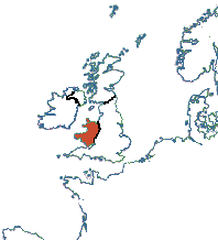 |
It's possible that some of the people reading this may not know where Llangynfelyn is. In fact, it's possible that a few may not even be sure where Wales is! For their benefit we present the attached maps and the following notes. Cymru (Wales in the Saxon tongue) occupies the central western peninsula of the island of Great Britain (off the coast of Western Europe) : bordered on the north, south and west by the sea, and on the east by England. |
|
Y mae Ceredigion (gynt Sir Aberteifi neu Cardiganshire, a cyn hynny yn yr Oesoedd Canol, gwlad Ceredigion) yn gorwedd ar arfordir gorllewinol Cymru, ar hyd y rhan ddeheuol Bae Ceredigion. Tua 70 km. o'r Gogledd i'r De, a rhyw 30 km o led ar y mwyaf, y mae arwynebedd o tua 1792 km.sg. ganddo. Yn 2001 y boblogaeth oedd 74,941. Aberaeron yw'r canolfan gweinyddol, ond Aberystwyth ac Aberteifi yw'r trefi mwyaf. Dros aber Dyfi i'r Gogledd yw Meirionydd; Powys sydd i'r Dwyrain, ac i'r De y mae Caerfyrddin a Sir Benfro. (Mae mwy o ystadegau ar gael ar wefan Ystadegau y Llywodraeth DU.) |
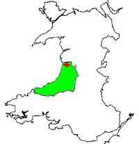 |
The county of Ceredigion (formerly Cardiganshire, and before that the mediaeval gwlad of Ceredigion) lies on the west coast of Wales, bordering the southern half of Cardigan Bay. About 70km from North to South, and 30km East to West at the widest, it is approx. 1792 sq.km. in area. The population in 2001 was 74,941. The administrative centre is in Aberaeron, but the two largest towns are Aberystwyth and Aberteifi (Cardigan). It is bordered on the north by Meirionydd (across the Dyfi estuary), on the east by Powys, and on the south by Caerfyrddin (Carmarthen) and Sir Benfro (Pembrokeshire). (More statistics at the UK Government Statistics website.) |
|
Y mae plwyf Llangynfelyn yn gorwedd yng Ngogledd Ceredigion. Mae Aberystwyth tua 15km i'r De ar hyd y A487, ac mae Machynlleth bron yr un pellter i'r Gogledd. Mae'r rheilffordd o Aberystwyth i Fachynlleth yn rhedeg drwy'r plwyf, ond y gorsafoedd agosaf yw Borth a Glandyfi. Nid oes porth neu faes awyr yn y plwyf. Mae'r plwyf yn cynnwys nifer o ffermydd ac anheddau unigol, yn ogystal â nifer o bentrefi, sef Tre-Taliesin, Tre'rddôl, Craig-y-Penrhyn a Goitre. Fe gafodd Tre-Taliesin ei enwi ar ôl Bedd Taliesin, sy'n cyfagos i'r pentref. |
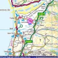 Cliciwch ar y map uchod am olwg mwy manwl. Click on the map above for a more detailed view. |
The parish of Llangynfelyn lies in the north of Ceredigion, about 15km north of Aberystwyth on the main A487 road, and the same distance south of Machynlleth. The railway from Aberystwyth to Machynlleth runs through the parish, but the nearest stations are at Borth and Glandyfi. There are no ports or airports in the parish. The parish contains a number of individual farms and dwellings, as well as several villages and hamlets, namely Tre-Taliesin, Tre'rddôl, Craig-y-Penrhyn and Goitre. Tre-Taliesin is named after the nearby grave of the poet Taliesin. |
|
|
| |
Y tirlun |
The landscape |
|
Mae nifer o fathau gwahanol o dir yn y plwyf. I'r dwyrain y mae bryniau, rhan o gadwyn Pumlumon, sy'n bron 500m o uchder (Moel Goch, 479m.) Rhan fwyaf y gorllewin yw cyforgors mawnog (Cors Fochno), wedi'i draenio yn rhannol heddiw, a thraethlin aber Dyfi. Rhwng y gors a'r bryniau y mae stribyn ffrwythlon o iseldir sy'n cael ei defnyddio ar gyfer ffarmio gwartheg a defaid, ac fel coedwigaeth. Mae'r rhan fwyaf y trigolion yn byw ar y stribyn canolog hwn, ar waelod y bryniau, a hefyd ar sawl 'ynysoedd' yn y gors. Mae Cors Fochno yn cael ei ddraenio gan Afon Leri (a gafodd ei droi yn gamlas ym mlynyddoedd cynnar y bedwaredd ganrif ar ddeg). Afon Cletwr hefyd yn rhedeg drwy'r plwyf o'r bryniau i lawr i aber Dyfi. Mae mapiau manwl y plwyf ar gael yma. |
The parish contains a number of different types of land. The eastern half is hill country, part of the Pumlimon range, rising to nearly 500m. (Moel Goch 479m.) Much of the western half is a raised peat bog (Cors Fochno), now partly drained, and the shoreline of the Dyfi estuary. In between is a fertile strip of lowland used mainly for sheep and cattle farming, and as forestry. The bulk of the population live on this central strip, at the base of the hills, and also on several 'islands' in the bog. Cors Fochno is largely drained by the River Leri (re-routed and canalised in the early 19th Century) which is the parish boundary to the west. The River Cletwr also runs through the parish from the hills to the Dyfi estuary. Detailed maps of the parish are available here. |
|
|
|
| |
Pobl y Plwyf - Cyfrifiadau 1991 a 2001 |
People of the Parish - the 1991 and 2001 Censuses |
Er nad oes modd gweld manylion llawn y cyfrifiad diwethaf, sef 2001, erbyn 2101, mae nifer o ystadegau wedi'i gyhoeddi eisoes. |
Although we can't see the full details of the latest census, 2001, until 2101, a number of statistics have been published already. |
1991 |
2001 |
||
|
Cyfanswm y poblogaeth |
616 |
641 |
Total population |
|
Dynion |
300 |
337 |
Male |
|
Merched |
316 |
304 |
Female |
|
Dan 16 oed |
20.5% |
20.6% |
Under 16 years old |
|
Pensiynwyr dan 75 oed |
10.9% |
9.4% |
Pensioners under 75 |
|
Dros 75 oed |
10.1% |
7.5% |
Over 75 |
|
Medru Cymraeg |
55.7% |
? |
Welsh-speaking |
|
Merched 16-59 mewn cyflogaeth |
67.7% |
|
Women 16-59 in employment |
|
Merched 16-74 mewn cyflogaeth |
|
56.8% |
Women 16-74 in employment |
|
Teuluoedd |
235 |
264 |
Households |
|
Perchnogion preswyl: perchen y tŷ yn llwyr |
41.7% |
|
Owner occupiers: own the house outright |
|
Perchnogion preswyl: brynu'r tŷ |
38.3% |
|
Owner occupiers: buying the house |
|
Perchnogion preswyl |
|
78.0% |
Owner occupiers |
Llogi o'r Cyngor ayyb. |
6.4% |
5.3% |
Renting from Council etc. |
Teuluoedd: pensiynwyr yn unig |
25.5% |
23.5% |
Households: pensioners only |
Teuluoedd: un berson yn unig |
24.7% |
26.1% |
Households: one person only |
Teulu un rhiant |
1.7% |
5.7% |
Single parent families |
Teuluoedd heb gar |
21.7% |
16.3% |
Households without a car |
Teuluoedd â 2 gar neu fwy |
30.6% |
39.8% |
Households with two cars or more |
Mae crynodebau y cyfrifiadau 1801-2001, a'r adroddiadau manwl i 1841-1901 ar gael ar dudalen y Cyfrifiad. |
Summary information from the census returns for 1801-2001, and detailed returns for 1841-1901 are available on the Census page. |
|
|
| |
Llangynfelyn neu Llancynfelin? |
Llangynfelyn or Llancynfelin? |
|
|
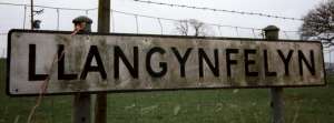
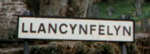
Mae sillafiad enwau Cymreig, yn arbennig yn eu ffurfiau Seisnigaidd nhw, byth wedi bod yn anghyson o braidd. Nid yw enw ein plwyf bach ni yn wahanol. Yn ôl rheolau gramadegol safonol, dylai'r enw fod 'Llangynfelyn, (sef Eglwys Cynfelyn Sant,) gyda threiglad llais ar enw'r sant. Ond, dros y blynyddoedd, mae nifer fawr o amrywiadau wedi bod, gan gynnwys Llanganfelin, Llangynfelin, Llancynfelin, Llancynfelyn, Llanganfeling, Llangafalon, Llan-gynvelyn, Llangaerfelin, Llancaerfelin a Llancynvelyn. Mae'r Cyfrifiad am ardalloedd eraill, Lloegr yn arbennig, yn tarddiad cyfoethog o amrywiadau, yn arbennig Weithiau, mae mwy nag un ffurf yn yr un dogfen! Gan amlaf ar y safle hwn, rydym wedi gadael sillafiad fel ag y mae yn y ddogfen wreiddiol. Hyd yn oed heddiw, nid yw'r Cyngor yn sicr pa sillafiad yw'r un cywir: mae llai na 50 llath rhwng yr arwyddion isod! |
The spelling of Welsh names, particularly their anglicised forms, has always been rather inconsistent. The name of our little parish is no different. According to the accepted grammatical rules, the name should be 'LLANGYNFELYN', i.e. the church of St Cynfelyn. The name of the saint should take a soft mutation, as it does in Llanfihangel (the church of Mihangel i.e. Michael), Llanfair (the church of Mair i.e. Mary) and Llangadog (St Cadog). However many variations have been used over the years, including Llanganfelin, Llangynfelin, Llancynfelin, Llancynfelyn, Llanganfeling, Llangafalon, Llan-gynvelyn, Llangaerfelin, Llancaerfelin and Llancynvelyn. A rich source of variations is the Census for other areas, particularly in England. In the documents on this site we have usually left the spelling as it is in the original document. Even the Council seem a bit unsure which is correct: the following two road signs are less than 50 yards apart! |
|
|
|
|
Mae enwau pentrefi y plwyf yn amrywio hefyd. Fe all Tre'rddôl ymddangos fel Trerddol, Tre'r Ddôl, Tre'rddol a.y.y.b. Hefyd fe all Tre Taliesin fod yn Taliesin, Tre-taliesin neu Talyasin. |
The names of the villages in the parish also vary slightly: Tre'rddôl can appear as Trerddol, Tre'r Ddôl, Tre'rddol etc. Even today Tre Taliesin can also be Tre-taliesin or just Taliesin. In older records Talyasin has been recorded. |
|
|
|
| |
Disgrifiad y plwyf, 1840 |
A description of the parish in 1840 |
LLANCYNVELYN (LLAN-GYNVELYN), a parish, in the union of Aberystwith, upper division of the hundred of Geneu'r-Glyn, county of Cardigan, South Wales, 9 miles (N. E. by N.) from Aberystwith, on the road to Machynlleth; containing 826 inhabitants. This parish, which abounds in mineral wealth, is situated on the river Dyvi, which is here navigable, and affords a facility for the exportation of lead-ore and bark, which are shipped from this place in great quantities, while timber, coal, and limestone, are imported for the supply of the neighbouring district. Mines of lead and copper are at present in operation, but to a very inconsiderable extent. The living is a perpetual curacy; net income, £83; patron and impropriator, J. P. B. Chichester, Esq. The ancient church, dedicated to St. Cynvelyn, a very ancient structure, and in a very delapidated condition, was originally erected in the sixth century, and is about to be rebuilt by voluntary subscription. There are places of worship for Calvinistic and Wesleyan Methodists. About 50 children are instructed in a day school at the expense of their parents; and there are three Sunday schools, supported by subscription, aided by gratuitous teachers, in one of which are 60 children who attend the Established Church; the others appertain to the dissenters, and afford instruction to 380 children. Mr. Thomas Owen, in 1731, bequeathed £10, the interest of which is distributed annually among the poor, according to the will of the testator. The total expenditure of the rates for the year ending March 25th, 1837, amounted to £194, of which £156 was for the relief of the poor, £11 towards county rates, and £27 for incidental charges.
Samuel Lewis, Topographical Dictionary of Wales (2nd ed., 1840), vol. iiMae nifer o ddisgrifiadau ychwanegol y plwyf ar gael yma. |
A number of other descriptions of the parish are available here. |
| Cwestiynau? Sylwadau? Beth ydych chi'n meddwl am y tudalen hwn a gweddill y wefan? Dywedwch yn y llyfr ymwelwyr. Questions? Comments? What do you think about this page and the rest of the site? Tell us in the guest book. |